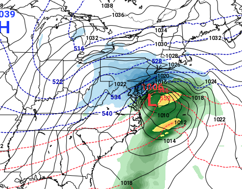
The GFS forecast model for Sunday, Jan. 13, 2019. (Credit: NOAA)
A significant snow storm could hit the Jersey Shore this weekend – or there may be nothing at all. But it’s still work keeping an eye to the sky, according to the experts, and the Internet has already begun throwing out phrases like “polar vortex” and “blizzard.” (We don’t like to do that sort of thing here, for the record.)
Meteorologists are watching two systems develop across the country. If the “perfect storm” of conditions develops, they could combine, form a coastal storm and bring the season’s first snow event to the Shore area since that “polar” air would be in place. Alternatively, the European forecast model is showing that the Garden State will dodge the bullet, and any snow would be relegated to our south.
“This one is going to boil down to an epic battle between a big mass of cold air and a strong coastal low pressure system,” local meteorologist Dan Zarrow said on his popular Facebook page.
Zarrow said the American forecast model is showing the potential for “double digit” snow totals, “but it is far from a guarantee” because forecast models are “all over the place.”
Another meteorologist, Joe Cioffi, agreed. His forecast is also a battle between the American mode, the GFS, and the EURO model.
“Were the European correct we would be looking at a flat wave that passes off the North Carolina coast and heads east northeast and good bye,” Cioffi said on his excellent Patreon page, explaining that the GFS times the arrival of cold Canadian air differently.
“All of this is coming on what looks like a terrific surface set up with a big cold high in Quebec and cold air wedged southward into the Middle Atlantic states,” he said.
Steven DiMartino, who runs the wildly popular NY-NJ-PA Weather website and social media accounts, is also watching the systems develop but has yet to make a formal forecast.
“Is there a shot? Yes,” he said with regard to a storm. “Is it time to go into details or go aggressive? No.”
I see some want to see me go nuts about Saturday into Sunday for snowfall. There’s a chance for some good snow, but beware of enhanced snowfall with positively titled troughs. Is there a shot? Yes. Is it time to go into details or go aggressive? No.
— NY NJ PA Weather (@nynjpaweather) January 7, 2019
As for timing, while the details of the combination of the two storm systems, as well as the injection of cold air the produce snow, is iffy – the timing is something we can prepare for.
The GFS model predicts the storm will strike Sunday morning to afternoon and move out overnight between Sunday and Monday.


Police, Fire & Courts
Thief Robs Toms River Restaurant, Pictured Walking Down Street Carrying Safe


Police, Fire & Courts
Intricate Nature of Toms River Jewelry Heist Revealed; TRPD Has Leads

Police, Fire & Courts
Toms River Police Investigating String of Overnight North Dover Burglaries


